There are mile markers, whether it be on the road of life or just your everyday commute, that signify where you are and how far you have traveled.
Most people are aware of Denver’s role in the early gold-seeking days but less know about the historic mile houses that marked the way to Denver City. A handful of these houses still exist.

In 1859, present-day Colorado was still a part of the Kansas Territory, not yet a part of the Union, and was pictured on maps as indigenous territory. Denver continues to be the homeland for several indigenous tribes, including the Ute, Arapaho, and Cheyenne.
During the summer of 1858, a group of Cherokee prospectors along with three brothers from Auraria, Georgia found gold near present-day Denver. This event became a key development in what we call the Pikes Peak gold rush (also known as the Colorado gold rush). Nowadays we associate Pikes Peak primarily with present-day Colorado Springs but to those traveling on foot or wagons along the dusty wagon roads—Pikes Peak represented the gateway to the gold mines—from present-day Colorado Springs all the way to present-day Denver.
Due to the increased population of white settlers and gold seekers, Colorado became its own territory in 1861 and later was admitted into the Union in 1876. Settlements such as Denver City, Boulder City and Colorado City became established towns.
Side note: Many locals know that Colorado means “colored red” in Spanish. However, what many may not know is that it was representatives from Colorado City (near Colorado Springs) who lobbied for the name Colorado.
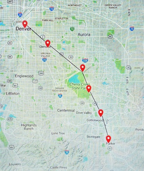
As you drive along Parker Road and Leetsdale Drive in the Denver/Glendale/Aurora/Parker areas, you are essentially riding atop an old pioneer trail called the Smoky Hill Trail. Named after the Smoky Hill River, which the trail follows most of the way, this was the most popular route for those traveling by foot, wagon, and eventually stagecoach from the eastern Kansas Territory to the gold fields.
Today, you can still trace the passageway of the Smoky Hill Trail. During the 1850s and 1860s, savvy business-minded homesteaders seized the new opportunities to profit from the increased volume of travelers. Like our modern-day rest areas and gas stations advertised along the highways, there were Mile Houses, often family-owned homesteads that were turned into public lodging or stagecoach stops.
The Mile Houses served as trail markers indicating how many miles remained until reaching Denver City, at today’s intersection of Colfax Avenue and Broadway.
Today, you can still visit two of the original Mile Houses, as well as tour the areas where a few of the others once stood.

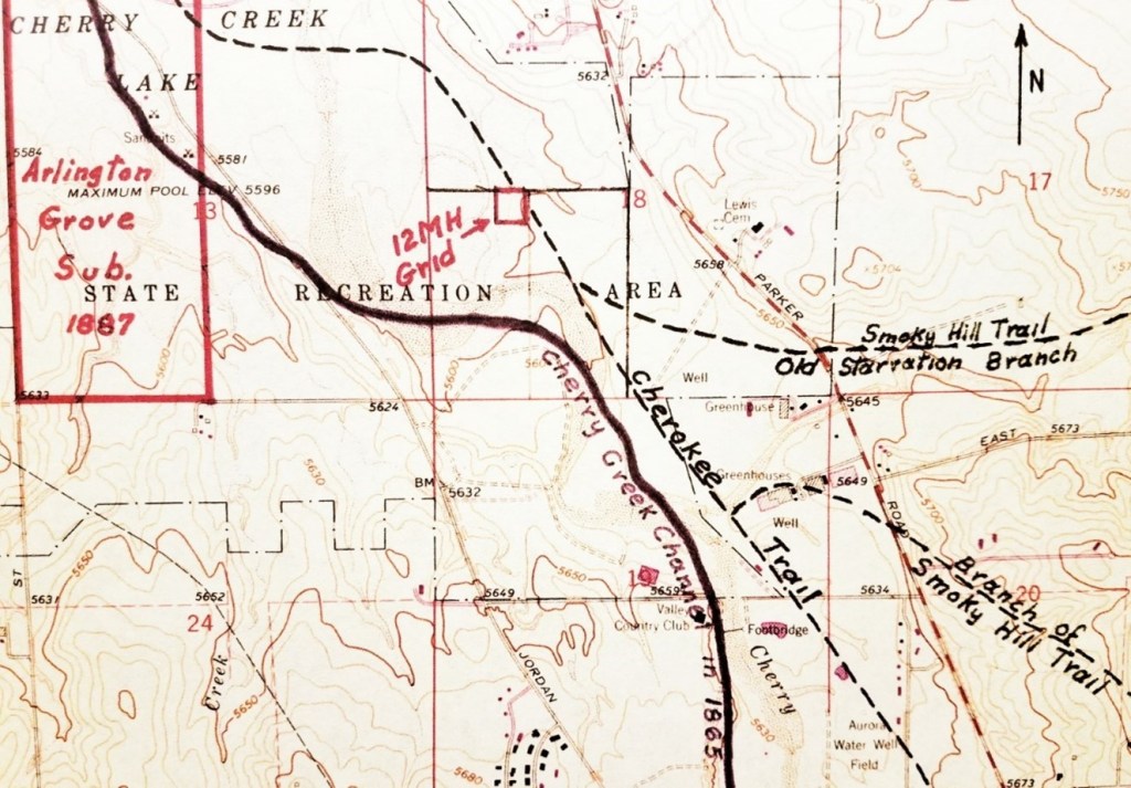
The Smoky Hill Trail was composed of three branches: north branch, middle branch, and south branch. Each of these branches veered in a westerly direction and connected to the Cherokee Trail. The southern branch of the Smoky Hill merged with the Cherokee Trail near the site of the 20 Mile House, these two trails are sometimes referred to interchangeably. (The Cherokee Trail is the older trail as it dates to 1849 with a group of Cherokee who were headed to the California gold rush). According to Lee Whiteley of the Cherry Creek Valley Historical Society, “…the six mile houses were located on the combined Cherokee-Smoky Hill trails.”
The Twenty Mile House
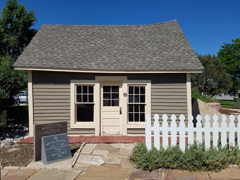
In 1864, Alfred Butters built a one-room log cabin near present-day Old Town Parker. Attached to his cabin was a makeshift post office for travelers to post notices or gather additional provisions. It became known as the Pine Grove Post Office. The old cabin was eventually torn down. However, the original post office area was restored by the Parker Area Historical Society and sits at the intersection of Main Street and Stage Run in Parker, Colorado. Today, visitors can see the post office and historic trail markers.

The Seventeen Mile House
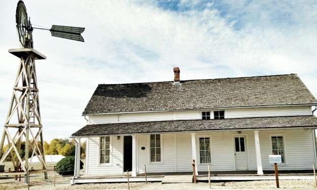
The Seventeen Mile House was built in 1862 by George C. Schleier, a former freight owner and former gold-seeker. He owned about 160 acres near present-day Parker Road and E. Long Avenue. It wasn’t until 1866 that new owner Mary Hightower turned the house into an inn for travelers.
The house transferred ownership several times and eventually was in danger of being torn down for development. The Cherry Creek Valley Historical Society helped to save the property from destruction. In 2000, the Trust for Public Land took ownership and shortly thereafter transferred the land to Arapahoe County. The Seventeen Mile House and surrounding 30 acres now belong to the town of Parker and Arapahoe County Open Spaces under a conservation easement. The Seventeen Mile House is a prime example of grassroots preservation where the community and local agencies have come together to preserve local history.
In 2012, the Seventeen Mile House opened its doors to the public for tours, open houses, and educational programming. Come visit the 17-Mile House!
Check their website for tours and events.
The Twelve Mile and Nine Mile Houses

Both the Twelve Mile House and Nine Mile House were located at the present site of Cherry Creek State Park. Nine Mile House sat near the intersection of Parker Road and I-225, near the edge of the present reservoir. Not much information exists on the Nine Mile House, except that it was a “small log cabin” and did not have a barn.
The Twelve Mile House was located near today’s Parker Road and East Orchard Rd (there is now a horse stable called Twelve Mile Stables near the vicinity of the old house). The Twelve Mile House was one of the larger hotels and like several other Mile Houses, it was common to host community dances. John and Jane Melvin, proprietors of the Twelve Mile House hosted dinners and dances for five dollars, including a five-piece orchestra. According to Margaret Long, “…the stage would stop once a day to drop off mail and change out their horses.”
Visit Cherry Creek State Park
Formerly known as Cherry Creek State Recreation Area and founded in 1959, it is Colorado’s first State Park. It has 35 miles of multi-use trails and offers opportunities for birdwatching, picnicking, boating, and camping!
Check out Cherry Creek State Park’s website for recreational activities and more information.
The Seven Mile House
Unfortunately, less information exists regarding the Seven Mile House. However, an excerpt from Margaret Long’s book The Smoky Hill Trail, stated that the Seven Mile House, “was formerly the O’Neil Ranch” and located on the “east bank of Cherry Creek and the west side of the valley road which runs parallel to Colorado 83 (Parker Road).”
The Four Mile House
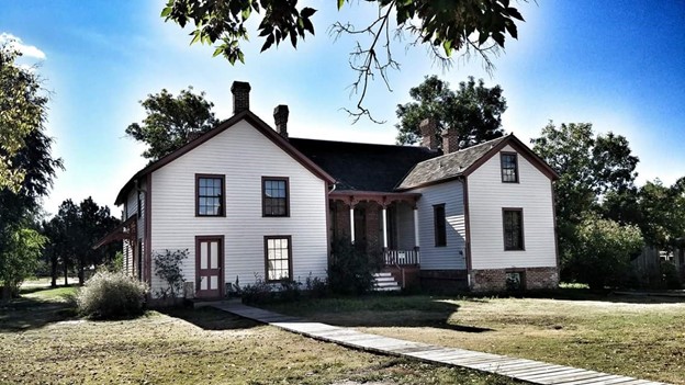
Just four miles from Denver City, this was the last stage stop before arriving in Denver. Built in 1859 by brothers Samuel and Jonas Brantner, it was eventually sold to Mary Cawker a year later. Cawker was a single mother, and she was the first to operate the log home as a stage stop. The property consisted of a tavern, parlor, and sleeping area that you can still tour today—thanks to historic preservation!
The Four Mile Historic Park hosts tours for the public, field trip opportunities, and seasonal events such as a summer concert series, pumpkin harvest festival, and Spirits & Spirits.
Check out their website HERE.
Denver City: End of the Line.

Much has changed since travelers walked the dusty road along the Smoky Hill Trail. However, several significant structures and mile markers remain, reminding us of where we have been and how far we have come.